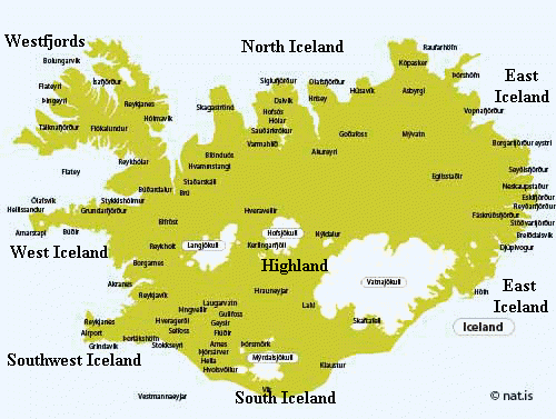
Maps of Iceland
For over 30 years, Nat.is has provided travellers in Iceland maps for planning trips around the country.
These maps have been made available with the kind permission from The National Land Survey of Iceland (Landmaelingar Islands)
Plan your trip responsibly – Study maps carefully and enjoy your trip to Iceland!
Articles in Maps of Iceland
https://natis/map-of-kjolur/
For information on road conditions, see... more
Map Snaefellsnes - Map Borgarfjordur - Map... more
Map North Iceland - Map East Iceland
Travel Guide East... more
:
Gullfoss & Geysir Area – South Iceland – Skaftafell &... more
Reykjavik Area - Reykjanes Area
Look for popular tours in Iceland
Map... more
Travel Guide Westfjords
Travel Guide Strandir
Maps North Iceland
Maps West... more
Maps:
Gullfoss & Geysir Area
South Iceland Lowlands -
South Iceland and... more
Maps:
Nortwest Hvamstangi to Blonduos Area -
Skagafjordur Area -
Akureyri... more
West Iceland are:
Borgarfjordur Area - Snaefellsnes Area - Budardalur... more
Maps East Iceland:
Vopnafjordur & Borgarfjordur Area - Central Eastern... more
Highland Maps and Route:
Kjolur Route
Sprengusandur Route
Kaldidalur... more
F-225
4 x4 vehicles only
LANDMANNA ROUTE
The Domadalur Route is... more
Map Sprengisandur Route
GAESAVOTN ROUTE
Robust 4 x4 vehicles only!
Off... more
The Cold Valley is the shortest of the three main roads across the... more
Map Gaesavotn Route
SPRENGISANDUR ROUTE,
( Route F-26 )
GAESAVOTN ROUTE... more
About The Kjolur Highland Route (Road F-35)
Remember! Off road driving is... more
Map Reykjavik Area
Map West Iceland - Map South Iceland
On March 19mars... more
Map Borgarfjordur area - Map Budardalur area
Travel Guide around... more
Map Snaefellsnes - Map Westfjords - Map Budardalur
Get an education when... more
Map Gaesavotn Route Map Sprenisandur Route Map North Iceland
More... more
Maps east Iceland
Maps North Iceland
Quick reference guide for North... more
Maps North Iceland - Map Raufarhofn area
Quick reference guide... more
Map Kopasker Raufarhofn area
Quick reference guide for North... more
Map Husavik area - Nortwest Hvamstangi to Blonduos Area – Akureyri... more
Map Skagafjordur area - Map Husavik area
Map Westfjords and... more
Vopnafjordur & Borgarfjordur Area – Southeast Area – Thorshofn and... more
Maps:
Vik and Kirkjubaejarklauistur <-Skaftafell & Jokulsarlon->... more
Maps:
Gullfoss & Geysir Area
South Iceland Lowlands
Skaftafell &... more
Maps:
Gullfoss & Geysir Area –
South Iceland and Highland... more
Maps:
South Iceland Lowlands
South Iceland and Highland
Skaftafell &... more